General Information
Nahiya (Subdistrict)
Cindires
Also Known As
Hechesna, Ĥec Ĥesena
Tribes
Xastiyan

Map and Location
Coordinates: 36.484665, 36.652524
Photos
Basic Information about Ĥec Ĥesna
Source: Tirej Afrin
Etymology: Hesen is the proper name of its first inhabitant, and Hec is his title
Foundation Date/Period: Approximately 400 years ago
Ruins: Xerba Qesîrê
Other Landmarks: Wadî Cercem
Summaries
I. Summary from TirejAfrin Site (English) of Ĥec Ĥesna
Source: https://www.tirejafrin.com/site/kura%20afrin%20Cindires%20-%20hec%20hesena.htm
Based on the book Çiyayê Kurmênc (Efrîn): A Geographical Study by Dr. Mihemed Ebdo Elî:
Hec Hesna Hac Hesenlî Hac Hesen.
Population: 1379. Area: 700 hectares. Distance: 12km. Elevation: 550m.
Regarding the name: Hesen is the proper name of its first inhabitant, and Hec is his title.
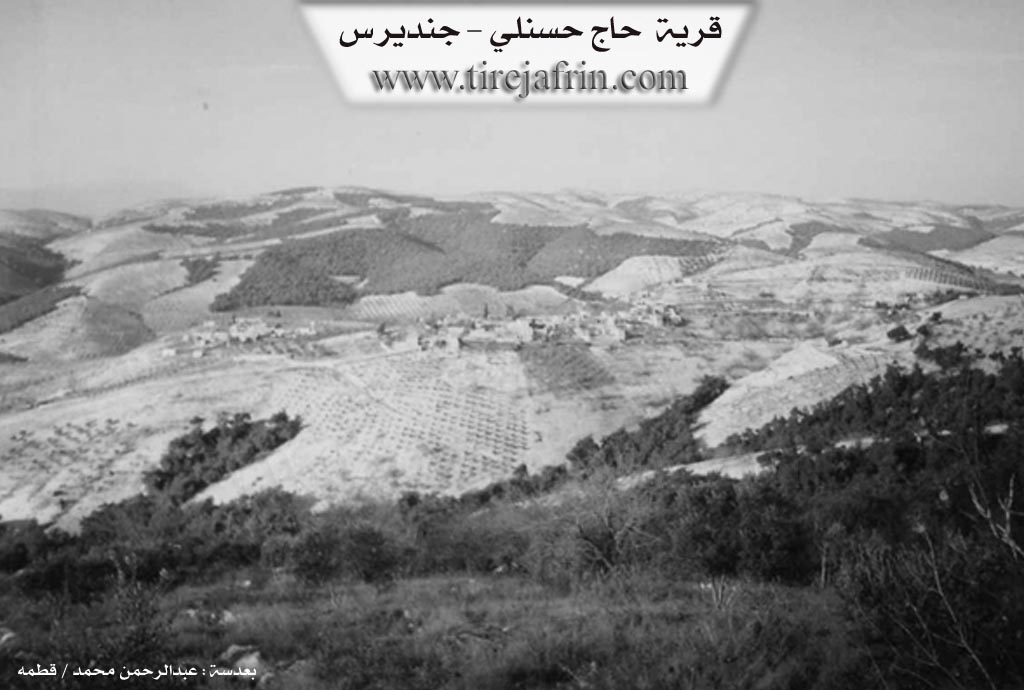
It is a small village consisting of two parts, western and eastern. It is located on a mountain slope from which several drainage lines descend, heading north and west towards Wadî Cercem. It is surrounded by dense pine forests and is considered the last village of the Xastiyan group from the west. Approximately 1km south of the village lies Xerba Qesîrê, which contains ancient archaeological remains, many pottery shards, carved stones decorated with inscriptions, column capitals, and cisterns hewn into the rock, which the residents still use to this day.
According to the book Efrîn... Her River and Her Green Hills by the writer Ebdulrehman Mihemed from the village of Qetme:
Hec Hesna is a village in Çiyayê Kurmênc, administratively belonging to the Cindirês subdistrict, Efrîn region, Heleb governorate. It is a large village situated on the western side of the middle section of the aforementioned mountain block, atop a mountain slope. Several drainage lines descend from it towards the west, feeding into Wadî Cercem. It is covered by oak forests and is located about 31km northwest of the town of Cindirês. Its soil is clay, suitable for agriculture and grazing.
The construction of the area is ancient, indicated by the presence of old archaeological remains such as pottery shards, carved limestone rocks decorated with inscriptions, and column capitals. It is bordered to the north by a rugged slope, Wadî Cercem, mountainous highlands, and the village of Remedana at the top of the valley. To the south, it is bordered by a rugged and harsh slope, three drainage lines, mountainous highlands planted with forest trees, and the villages of Teteran and Kefer Sefrê. To the west lies a rugged slope, the meeting point of drainage lines at the bottom of the valley, the village of Sînka, and the town of Şiyê. To the east, there is a high, rugged mountain chain planted with forest trees, and the villages of Koran and Çobana.
The number of houses is approximately 80, and the village is about 400 years old, according to one of the elderly residents. The old houses are made of stone and mud with flat wooden roofs, though modern concrete dwellings have begun to dominate and extend along the transportation axis. A electricity network and a primary school are available. There is also a telephone center in the village used by all residents. The drinking water network is supplied by a well drilled by the state or from cisterns hewn into the rock, which residents still use today in Xerba Qesîrê, located 2km south of the village, where rainwater is collected.
Its residents work in rain-fed agriculture on an area of 700 hectares, cultivating olive trees, grains, legumes, fig trees, pomegranates, walnuts, and vines, alongside raising sheep and goats. The Riya Mabeta (road to Mabeta) leading to the village has been newly asphalted through the mountains, and the road towards Kefer Sefrê and the town of Cindirês is asphalted.
Village Mukhtar: Mistefa Mihemed.
Sources:
- Book: جبل الكرد (عفرين) دراسة جغرافية Çiyayê Kurmênc (Efrîn): A Geographical Study by د. محمد عبدو علي Dr. Mihemed Ebdo Elî.
- Book: عفرين .... نهرها وروابيها الخضراء Efrîn... Her River and Her Green Hills by عبدالرحمن محمد Ebdulrehman Mihemed from the village of Qetme.
Preparation and Execution:
- Manager of Navenda Tirej Efrîn: Ebdulrehman Hacî Osman
- 20/12/2013
II. Summary of Ĥec Ĥesna from Khalil Sino
Source: https://www.youtube.com/watch?v=VciNU_wrqxw
The documentary presented by the channel Hatin li Efrînê explores the village of Hec Hasna a Jêrîn, also referred to locally as Heşhesnê, located in the broader Efrîn region. Hosted by Xelîce Sîno from the village of Baedîna, the episode captures the daily lives and personal histories of the residents during the holy month of fasting. Supported by viewers from the diaspora, including a sponsor named Aliya living in Almanyayê with ties to the village of Meydanê, the film crew aims to share an evening meal with local households while documenting their stories.
The village of Hec Hasna a Jêrîn appears as a quiet and resilient rural community where elderly residents navigate the physical and emotional challenges of age, illness, and loss. The host first visits an elderly woman named Wedha, commonly known as Dayîka Hemûde. She is the widow of Ebd Elqasim. During their conversation, Wedha discusses her failing health and the collapse of her traditional baking oven over a year ago. She explains the difficulties of getting medical treatment, which requires costly travel to the larger town of Cindirêsê. Her family is dispersed, with one son having moved to Cindirêsê and another working at the market in the neighboring village of Çolaqa.
Following this encounter, the host meets another elderly resident named Meryem. Originally from the village of Tirmîşan, Meryem reveals that she relocated to Hec Hasna a Jêrîn after an arranged marriage. She reflects on her fate and recounts her earlier years working as a seamstress in the city of Helebê to support herself. She is currently grieving the loss of her husband, who passed away five years prior, and expresses deep sorrow and loneliness. Despite her profound sadness, she finds solace in the daily support of her extended family and neighbors, illustrating the tight social bonds that sustain the elderly in rural Efrîn.
The documentary then shifts focus to the local village economy as the host visits a grocery store managed by a man named Kamîran. The host purchases various essential food items such as dates, rice, sugar, oil, eggs, and bulgur. These provisions are bought with the intention of distributing them to three vulnerable families in the village. This transaction provides a practical glimpse into local commerce and the current prices of basic goods in Heşhesnê. The television crew, including cameramen Hoşyar, Şêrvan, and Beşîr, concludes the visit by distributing the food supplies, reading a prayer for the deceased at the village graveyard, and expressing gratitude for the warm hospitality shown by the people of Hec Hasna a Jêrîn.
II. Ax û Walat Book 1
221
THE VILLAGE OF HECHESNA
30.12.2016
The village of Hechesna is the last village in the Xastiyan mountain range from the west. It is affiliated with the Şiyê district of Efrîn canton, located 10 km southeast of the town of Şiyê and 26 km northwest of the city of Efrîn. That is, it is located between the three districts of Mabeta, Cindirêsê, and Mabeta.
The village of Hechesna is adorned with the surrounding pine forests. The name of the village comes from the name of the first person who settled in the village, and he was named ((Hec Hesen)).
222
He was from the Milî tribe. Later, other families came for the work of charcoal and making poles from the surrounding forests and were forced to settle in the village. Among those families: Egêdat who are originally Arabs, Hevîdî who came not long ago, the Piçalê family and Silêmên from the village of Xilalka.
To the east of the village is the Şata valley and mountain, which contains a pine forest. To the south are Xirabê Qusîrî, Pozê Erdik, and Rezê Xelîl. To the west are Cirnikê, Qumîrî, Ekûrkê, Xirabê Çîtliqê, Xirêbe, the village of Senarê, and the Kanûşkê spring. To the north are the Dolê valley, Gola Êş, the village of Remedana, and the village of Dimiliyayê Cûmê, where no one lives now and it has become ruins.
The Ekûrkê forest is the largest pine forest in the Efrîn canton. It is all pine trees along with some hawthorn, terebinth, and avirsê bushes. It is a natural forest, but in 2006 it caught fire, and despite efforts to extinguish it, the entire forest burned down.
The forests around the village have improved the weather conditions of the region and made the area a place for trips, tours, and excursions.
There are nearly 100 houses and around 1500 people living in the village, but for various reasons, many families have moved away.
There are 15 families in the village:
223
The families of Seydikê Mele, Ne’so, Ne’sê Ûsê, Reşîdê Çawîş, Mistê Eşê, Hemûdî, Piçalê, Gulkewê, Mistê Azê, Bekî Hesê, Selmên, Me’mê Birîm, Simo, Hemîdê Şêxo, Mûsê.
All families get along in good harmony and relations, and in joys and sorrows, they all help each other.
The people of the village make their living from agriculture, and the cultivation of olive fields is the main work. Due to the presence of pastures, many families own livestock such as sheep and goats. There are 2 chicken farms in the village, and 5 people work there and support their families. Nearly 50 people also work in the institutions and agencies of the Democratic Autonomous Administration. Around 30 people work in various workshops in the cities of Cindirêsê and Efrîn.
The farmers of the village face great difficulty in servicing their fields because all the fields are mountainous, so they are plowed with animals or livestock.
There are 2 martyrs from the village:
Şehîd Bedran and Ş. Ferat. The village commune is also named Ş. Dilar and the school is named Ş. Ferat.
224
Simo and Hemîdê Şêxo were two well-known social figures in the village, and their homes were a place for guests and travelers, and they were very hospitable.
The Dolê Valley Road is an old road; in the past, it was a main road that went from Reco to Hemamê and Rihaniya on the border.
The village's guesthouse, named ((Tebeqê)), was the place for guests and gatherings of the village people.
The village of Hechesna is famous for its abundance of caves, and this is an indicator that this village is very old. One of the ancient areas is Xirabê Qusîrê, which is known as an ancient city to the south of the village. There are many caves, cisterns, and collapsed buildings there.
It is worth mentioning one interesting thing in the village, which is that for a long time and until now, many people are masters of stone and construction, meaning they are experts in the work of building houses, and they have inherited this skill from their fathers and grandfathers.
Transcriptions and Subtitles
| Source | Video | Subtitles | Transcript |
|---|---|---|---|
| Khalil Sino 1 | Watch Video | Download SRT | View Transcript |